Property & Access
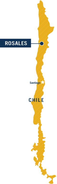
The Rosales Project includes 3444 hectares of 100% held mineral claims (Figure 1. Project Location & Targets). The project is road-accessible and is situated less than 90 kilometres from the mining centre of Copiapo, with world-class exploration and mining infrastructure readily available.
The Project is situated in the Atacama Region, a prolific mining region that hosts multiple large precious and base metal mines. Large mineral deposit types in the area include: iron-oxide copper gold (Candalaria, Mantos Verde), porphyry copper-gold (Inca del Oro), epithermal gold-silver (El Peñon, Guanaco) and Maricunga gold deposits (Cerro Casale-Caspiche, Refugio, Marte, Maricunga).
Geology and Mineralization
[For full details of exploration results, please refer to the original News Releases.]
The Rosales Project is underlain by Jurassic-aged volcanic-sedimentary sequences, overthrust to the east by Triassic aged sediments. These sequences were later intruded by a dacitic dome and related felsic dykes, of probable Paleocene-Eocene age. Finally, a sinistral strike-slip fault system was emplaced to the east of the project where the Margarita Mine is found.
The initial reconnaissance program at Rosales identified two general areas of prospective mineralization: The Margarita Mine trend (MMT), and the NW Target (see Figure 1).
The MMT is a 3.5-kilometre-long structural corridor, oriented northeast-southwest, mainly defined by a felsic dyke.
Situated within the corridor, the Margarita Mine is a small operating underground mine with mineralization known to extend to at least 200 metres depth; the mined zone is open at depth. Plus 1% copper values are hosted in crackle breccias and veins along lithologic boundaries and fault traps, extending outwards from the structural corridor up to 200 metres. [Golden Arrow cautions that proximity to a mining operation does not indicate that mineralization will occur in sufficient quantity or grade on Golden Arrow's property that would result in an economic extraction scenario.] Along the trend within the Rosales concessions, chalcocite and chrysocolla were identified in outcrop, filling fractures and disseminated in the andesites, in an area covering 100 x 200 metres. Samples from this area averaged 2.53% copper with a highest value of 4.37 % Cu. There are further indications of a manto-type mineralization two to four metres thick in this zone.
Additionally, mapping interpretation suggests that the projected strike extension of the MMT to the southwest on the Rosales concessions should intercept a limestone unit at the base of the Jurassic sequence which could be a prospective host for replacement-style copper mineralization. This conceptual target will be further evaluated with geophysical methods.
The NW Target is located 2.7 kilometres to the northwest of the MMT. It includes outcrop with veinlets and fractures hosting quartz-chalcocite-copper oxides within an area measuring 1,500 by 400 metres. This mineralization is hosted by porphyritic andesite and dacite, which may represent a dome complex. Eight chip samples averaged 3.19% Cu and 13.9g/t Ag with a highest value of 5.74% Cu and 37.1g/t Ag. The anomalous silver values together with the presence of low temperature opaline-silica veinlets in the dacite suggests a possible epithermal system at depth.
In Q3 2020 Golden Arrow initiated a detailed program of soil sampling and mapping of these two main target areas.
The Opportunity
The Rosales Copper Project is 100% held by Golden Arrow. The Project has several priority target areas characterized by zones of near-surface copper stockwork mineralization, potentially related to larger mineralized systems at depth. Located in the prolific Atacama mining area of Region III, Chile, Rosales benefits from intensive local mining and exploration infrastructure.
Highlights include:
- Multiple targets along-trend with a small-scale underground copper mine, with mineralized occurrences returning up to 4.37% copper in reconnaissance sampling
- Additional target 3km to the northwest with up to 5.74% copper in reconnaissance sampling
[Golden Arrow cautions that proximity to a producing mine does not indicate that mineralization will occur in sufficient quantity or grade on Golden Arrow's property that would result in an economic extraction scenario.]
Property & Access
The Rosales Project includes 800 hectares of 100% held mineral claims with another 2920 hectares under sole application which are expected to be granted to Golden Arrow. The project is road-accessible and is situated less than 90 kilometres from the mining centre of Copiapo, with world-class exploration and mining infrastructure readily available.
The Project is situated in the Atacama Region, in a prolific mining region that hosts multiple large precious and base metal mines. Large mineral deposit types in the area include: iron-oxide copper gold (Candalaria, Mantos Verde), porphyry copper-gold (Inca del Oro), epithermal gold-silver (El Peñon, Guanaco) and Maricunga gold deposits (Cerro Casale-Caspiche, Refugio, Marte, Maricunga).
Geology and Mineralization
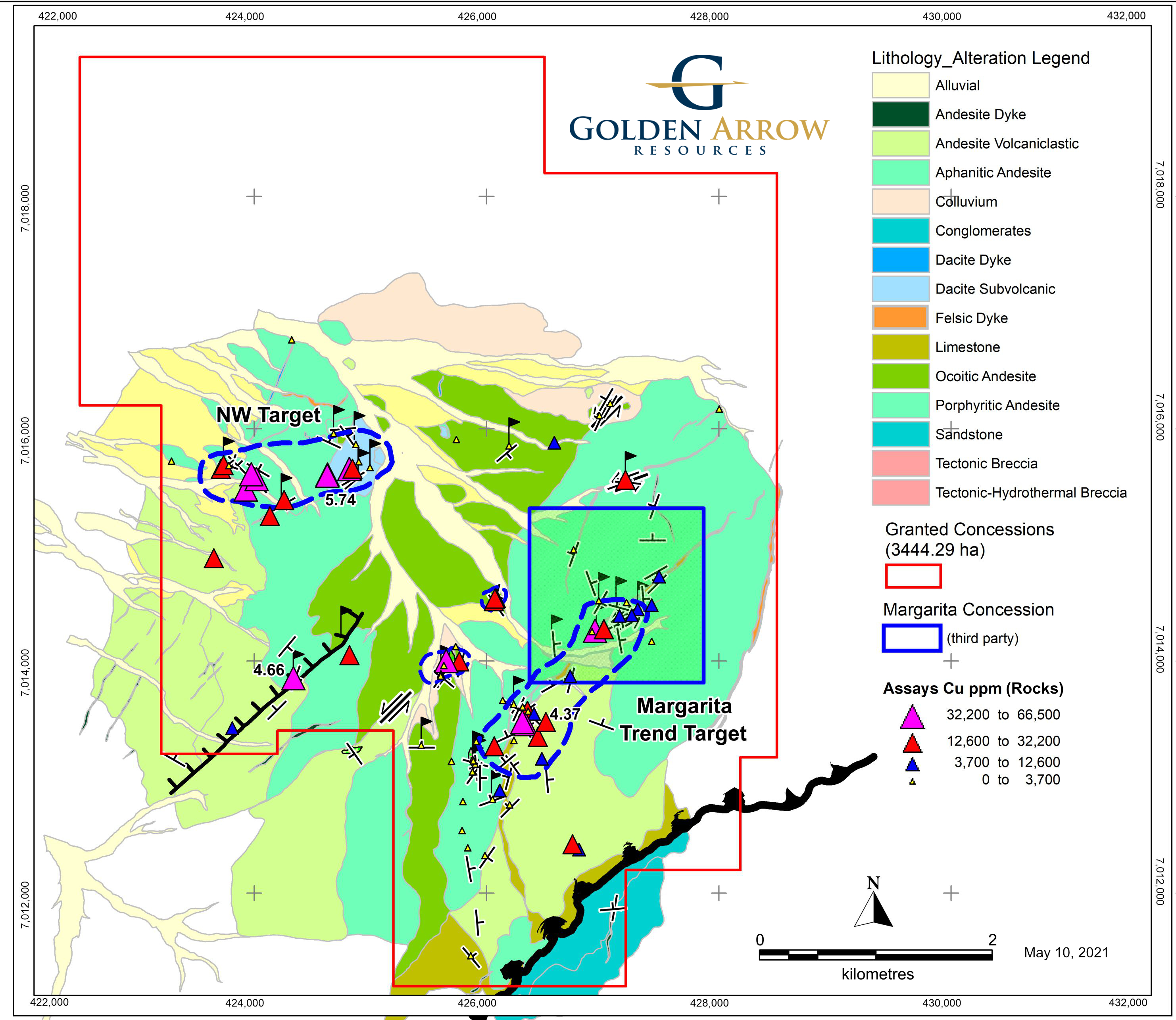
Figure 1 Rosales Concessions and Reconnaissance Sampling Results. See News Release dated July 16 2020.
The Rosales Project is underlain by Jurassic-aged volcanic-sedimentary sequences, overthrust to the east by Triassic aged sediments. These sequences were later intruded by a dacitic dome and related felsic dykes, of probable Paleocene-Eocene age. Finally, a sinistral strike-slip fault system was emplaced to the east of the project where the Margarita Mine is found.
The initial reconnaissance program at Rosales identified two general areas of prospective mineralization: The Margarita Mine trend (MMT), and the NW Target (see Figure 1).
The MMT is a 3.5-kilometre-long structural corridor, oriented northeast-southwest, mainly defined by a felsic dyke.
Situated within the corridor, the Margarita Mine is a small operating underground mine with mineralization known to extend to at least 200 metres depth; the mined zone is open at depth. Plus 1% copper values are hosted in crackle breccias and veins along lithologic boundaries and fault traps, extending outwards from the structural corridor up to 200 metres. Similar mineralization has been found in this part of the trend on the Rosales property at surface. Chalcocite and chrysocolla was identified in outcrop, filling fractures and disseminated in the andesites, in an area covering 100 x 200 metres. Samples from this area averaged 2.53% copper with a highest value of 4.37 % Cu. There are further indications of a manto-type mineralization two to four metres thick in this zone.
Based on geological mapping interpretation, the projected strike extension of the MMT to the southwest on the Rosales concessions should intercept a limestone unit at the base of the Jurassic sequence which could be a prospective host for replacement style copper mineralization. This conceptual target will be further evaluated with geophysical methods.
The NW Target is located 2.7 kilometres to the northwest of the MMT. It includes outcrop with veinlets and fractures hosting quartz-chalcocite-copper oxides within an area measuring 1,500 by 400 metres. This mineralization is hosted by porphyritic andesite and dacite, which may represent a dome complex. Eight chip samples averaged 3.19% Cu and 13.9g/t Ag with a highest value of 5.74% Cu and 37.1g/t Ag. The anomalous silver values together with the presence of low temperature opaline-silica veinlets in the dacite suggests a possible epithermal system at depth.
Reconnaissance sampling also detected four other showings with mineralization in old pits as shown within blue outlines in Figure 1. Six samples returned values ranging from 1.42% to 4.66% Cu.
For full details on the exploration program and results, please refer to the News Releases page.